Monthly Archives: September 2012

Tagaytay-Killer Loop

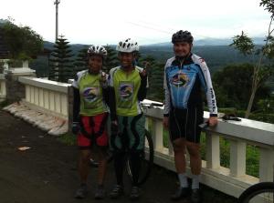
The 3 Explorers- me the only thorn amongst the roses with Lea Latayan and Deo Cas.

Short but deadly- that is how I will describe the Tagaytay Killer Loop. These are series of routes that takes you down and up (or up and down depending on the start of the route) from the Tagaytay Ridge to the Taal Lake coastline. Its a great climbing training that is short and not-sweet; ideal for a quick workout for those on a weekend vacation on this resort town.

Two prominent routes composes this loop- the Tagaytay-Talisay Road. The small road that starts from the prominent Tagaytay Rotunda. Its a longer 12-15km stretch and its better to go down this way as its harder to do this going up. And the Ligaya Drive, or what locals fond of calling Sungay (horns as translated

The best way to end one hard ride- replenish the lost fats by eating Bulalo.

in English). Not sure where they got this name but for me, this Sungay is an appropriate name for this one hell of a route.  Weekend motorcycle enthusiasts talks about the capability of their motorcycles to climb this route so that is a clear proof that this is a challenging climb. Its shorter than the Tagaytay-Talisay route by 2-3 Kilometers so its still better to take this one going up. This road is the one that goes down from the Development Academy of the Philippines (DAP) facility in Tagaytay. So coming from Manila via Santa Rosa- the Ligaya route is to your left while the Tagaytay-Talisay route is to your right as you exit Santa-Rosa-Tagaytay Road.

If the intent is to just do a day tour here- you can park in any of the restaurants in Tagaytay. Other options for a longer route includes the Taal Lake Loop circling the entire Taal Lake or to use any of these two routes going down and go further towards Agoncillo for a climb via Payapa route (see Payapa entry in this blogsite).

The Route:

Tagaytay- Sungay

Tagaytay Sungay Loop

For more map details please visit my Everytrail at: http://www.everytrail.com/my_trips.php?user_id=46765 

Loving Caylabne


The views near the gate of Caylabne.

Parked at NAIC municipal Hall. The total route is about 30 kilometers one way so 60 kilometers total back and forth. This is one of the best biking destination- manageable climb (like Bugarin), awesome view, ample foliage for shade against the sun, great asphalt condition- like the oval track tartan (as of writing) and secure (passing by the Marines Naval camp). To get access inside Caylabne Resort, you can ask the guard for pass; in our case we had our lunch in their restaurant but not sure if they will give you pass if you will not eat at their restaurant. There is an almost complete (few sections still being constructed) route going to Nasugbu (with tunnel cutting the mountains) so in the future, a Tagaytay-Alfonso-Naic-Ternate-Nasugbu-Tagaytay loop is possible. The route passes by Mt. Palay-

Waiting for hand-outs. Monkeys are one of the common wildlife encounter near the Caylabne area.

palay with a popular hiking destination- Pico de Loro (Parrot’s Beak). In fact you can bike-hike the route as there is access to Nasugbu from the base of the mountain. We originally planned to take a short hike to Pico but we found we had little time to add that to our itinerary. Another option is to just ride to a small waterfalls near the trail head of Pico. Pico de Loro is site to a new resort type residential development by SM Properties. The only concern doing this route is the bad traffic in Cavite. CaviTex is a big help but there are still a lot of choke points. So in the future, when the Nasugbu-Ternate link is built, we think its better to go to Nasugbu and bike to Caylabne- better yet, do the proposed loop as mentioned.

Adventure Time! The team- (L-R) Long Henson, Roy Lopez, Deo Cas, Lea Latayan and Dindo Narciso.

The Route:

Caylabne

Naic to Caylabne

For more map details please visit my Everytrail at: http://www.everytrail.com/my_trips.php?user_id=46765